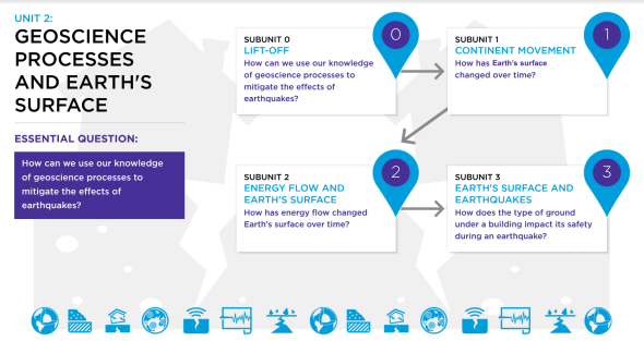
7th Grade - Unit 2: Geoscience Processes and Earth's Surface

Subunit 1: Continent Movement

Below you will view and download:

🟦 Subunit Assessment Opportunities 

🟦 5E Lesson Sequence

Subunit 1: Assessment Opportunities

Subunit 1 Assessment Opportunites


View and download (by making a copy)- Subunit 1 Assessments

What should my students know and be able to do?
What should I prioritize?

Note: The materials below are personal recommendations from teachers in the field.
Feel free to consider your context when deciding whether to follow these suggestions.

Instructional Sequence

Assessment Types at
This Stage

Assessment Description

Learning Target

Engage

Observations and Predictions: Students’ background knowledge about changes to Earth’s surface over time are assessed. Students consider this change at different time and distance scales: 1) locally versus Earth as a whole and 2) relatively recent changes (15,000 years) versus those in all of Earth’s history (4.5 billion years).

In Part 1, students look at maps of the San Francisco Bay Area at present and from 10,000 and 15,000 years ago. They should note the changes that have happened and consider why they happened. In Part 2, students look at a map of Earth and think about how the land might have changed over the past 4.5 billion years.

At this point, it is okay if students do not think the Earth has changed at all over its history. The purpose of this lesson is to access background knowledge and familiarize students with the seven continents. 

Explore

Observations and Predictions: Students analyze several maps and use the evidence the maps provide to consider whether the continents have moved over time. 

Students begin to identify sources of evidence that the location of the continents has changed over time. This includes fossils, rocks, coal formation, and continent shape data.

Students should be able to

  • Consider whether the maps provide evidence that the continents have moved over time.

Explain

Reading, Group Discussion, and Engaging in Argument From Evidence: Students read an article about Wegener’s idea of continent movement. They discuss the article with a partner and the class. Students then complete a Claim, Evidence, Reasoning table for the claim that the continents have moved over time. 

Students read an article about Wegener’s theory about continents. Students will use a Claim, Evidence, Reasoning table to organize the evidence about continent movement.

Students should be able to 

  • Identify multiple sources of evidence that the location of the continents has changed over time. This includes fossils, rocks, coal formation, continent shape, and climate zone data.

Elaborate

Applying Understanding to a New Context and Engaging in Argument From Evidence: Students build on what they have learned about the movement of continents by considering new evidence and making Connections to the Culminating Project.

Students analyze a map showing the movement of GPS receivers over time and determine if it supports or refutes the claim that the continents are still moving today. Students then consider how the movement of continents could affect the earthquake safety of the housing development location.

Students should be able to use new evidence to create an argument about whether the continents are still moving today and

 apply their understanding of continent movement to the San Francisco Bay Area and the Culminating Project.

Evaluate

Obtaining, Evaluating, and Communicating Information; Engaging in Argument from Evidence: Students demonstrate their understanding and evaluate their own knowledge of the evidence supporting the movement of continents over time.
 

Students revise an argument to include the evidence for the movement of continents over time. Students update their driving question board to communicate their understanding of the subunit’s topics.

Students should be able to

  • Critique, correct, and clarify an incorrect statement about the laws of motion.
  • Work together as a class to update the Driving Question Board with the content covered in Subunit 1.
  • Identify multiple sources of evidence that the location of the continents has changed over time. This includes fossils, rocks, coal formation, and continent shape data.

View and download (by making a copy)- Subunit 1 Assessments

Subunit 1: 5E Lesson Sequence

Subunit Description


📂 Download ALL lessons at one time for Unit 2: Subunit 1 from this folder. 📂

In this subunit, students gather evidence to support the argument that the continents have moved over time and are still moving today. They will use maps, diagrams, continent puzzle pieces, and articles as their sources.

Lesson Lesson Name Teacher Document Student Handout
1 Engage

7.2 SU1 1Engage Teacher

7.2 SU1 1Engage Student

2 Explore

7.2 SU1 2Explore Teacher 

7.2 SU1 2Explore Student

7.2 SU1 2Explore Graphic Organizer HO

AMNH_dinos_plate_tectonics

3 Explain

7.2 SU1 3Explain Teacher

7.2 SU1 3Explain Student

4 Elaborate 7.2 SU1 4Elaborate Teacher

7.2 SU1 4Elaborate Student

5 Evaluate

7.2 SU1 5Evaluate Teacher

7.2 SU1 5Evaluate Student


📂 Download ALL lessons at one time for Unit 2: Subunit 1 from this folder. 📂

Subunit 2: Energy Flow and Earth's Surface

Below you will view and download:

🟦 Subunit Assessment Opportunities 

🟦 5E Lesson Sequence

Subunit 2: Assessment Opportunities

Subunit 2 Assessment Opportunites


View and download (by making a copy)- Subunit 2 Assessments

What should my students know and be able to do?
What should I prioritize?

Note: The materials below are personal recommendations from teachers in the field.
Feel free to consider your context when deciding whether to follow these suggestions.

Instructional Sequence

Assessment Types at
This Stage

Assessment Description

Learning Target

Engage

Predictions and Observations: Students’ background knowledge about the mechanism behind continental movement is accessed.

Students first predict what has caused the continents to move over time. They review their understanding of the effect of thermal energy transfer on matter by considering a demonstration from Unit 6.1. Using this understanding, students review a diagram showing energy transfer within Earth and consider how this might affect matter at Earth’s surface.

It is okay if students are not sure about their ideas at this point. The purpose of the lesson is to get students to brainstorm ideas about why continents have moved over time and connect their understanding of thermal energy transfer to changes at Earth’s surface.

Explore

Observations and Inferences: Students observe a demonstration that serves as a model of what happens when energy flows within Earth. Students try to connect what they observe with a diagram of energy transfer within Earth.

Students reflect on their observations of the demonstration and consider how it might be similar and different from what happens on Earth.

Students should be able to 

  • Observe that energy transfer from a hot plate leads to movement in a soap solution. This movement follows a pattern of rising to the top and falling back to the bottom.
  • Begin to apply the pattern of movement they saw in the demonstration to matter within Earth and at Earth’s surface.

Explain

Reading, Group Discussion, Written Responses, and Using Models to Show Understanding: Students read an article about how the geoscience processes of convection currents and plate tectonics have changed Earth’s surface over time and cause earthquakes. They use this article and other evidence from the subunit to create models of different plate boundaries. 

Students read an article and  answer questions about why the continents have moved over time. They then use sandwich cookies to model the different types of plate boundaries.

Students should be able to 

  • Explain how the geoscience processes of convection currents and plate tectonics have led to the movement of continents over time.
  • Identify and model the three types of plate boundaries: convergent, divergent, and transform.
  • Explain the effects of plate movement, including earthquakes.

Elaborate

Extending Understanding and Applying Learning to a New Context: Students build on what they have been learning about plate boundaries and earthquakes. They also connect their understanding to the Culminating Project.

Students will analyze diagrams showing the factors that place the San Francisco Bay Area at risk for earthquakes. Following this, they will choose three locations for their housing development based solely on the criteria of distance from a plate boundary.

Students should be able to 

  • Explain the geoscience processes that lead to earthquakes in San Francisco. (Convection currents inside Earth lead to plate movement. San Francisco is located at the boundary of the North American and Pacific Plates. This is a transform boundary where the plates grind past each other. While they do this, pressure builds. Eventually, the rocks that make up the plates break and release the pressure as an earthquake.)

Evaluate

Obtaining, Evaluating, and Communicating Information; Engaging in Argument from Evidence: Students demonstrate their understanding and evaluate their own knowledge of plate tectonics.


Using a diagram and evidence from the subunit, students construct an argument about which of two locations would be most likely to experience an earthquake. Students analyze another diagram and explain the geoscience processes that they observe.

Students should be able to 

  • Demonstrate their understanding of how geoscience processes—driven by energy flow—have changed Earth’s surface over time.

View and download (by making a copy)- Subunit 2 Assessments

Subunit 2: 5E Lesson Sequence

Subunit Description


📂 Download ALL lessons at one time for Unit 2: Subunit 2 from this folder. 📂

In this subunit, students will learn the two geoscience processes behind continental drift: convection currents within Earth’s layers and plate tectonics.

Lesson Lesson Name Teacher Document Student Handout
1 Engage

7.2 SU2 1Engage Teacher

7.2 SU2 1Engage Student

2 Explore

7.2 SU2 2Explore Teacher 

7.2 SU2 2Explore Student

3 Explain

7.2 SU2 3Explain Teacher

7.2 SU2 3Explain Student

7.2 SU2 3Explain Graphic Organizer HO

4 Elaborate 7.2 SU2 4Elaborate Teacher

7.2 SU2 4Elaborate Student

5 Evaluate

7.2 SU2 5Evaluate Teacher

7.2 SU2 5Evaluate Student


📂 Download ALL lessons at one time for Unit 2: Subunit 2 from this folder. 📂

Subunit 3: Earth's Surface and Earthquakes

Below you will view and download:

🟦 Subunit Assessment Opportunities 

🟦 5E Lesson Sequence

Subunit 3: Assessment Opportunities

Subunit 3 Assessment Opportunites


View and download (by making a copy)- Subunit 3 Assessments

What should my students know and be able to do?
What should I prioritize?

Note: The materials below are personal recommendations from teachers in the field.
Feel free to consider your context when deciding whether to follow these suggestions.

Instructional Sequence

Assessment Types at
This Stage

Assessment Description

Learning Target

Engage

Predictions and Observations: Student’s background knowledge about the effects of earthquakes on buildings and factors that may influence the effects are assessed.

Students look at photographs of two different buildings after the Loma Prieta earthquake. One is destroyed and the other is intact. Students brainstorm ideas about what caused the different effects.

Students do not have to come up with correct ideas in this lesson. The purpose is to get them thinking about the variables that affect the strength of shaking at a location during an earthquake.

Explore

Observations and Inferences: 

Students look at a map of San Francisco showing that many different soils made of different types of rock are present. They then observe several models of how rocks are formed and weathered. 

Students reflect on how energy transfer affected the rocks in their models. 

Students should be able to

  • Make a connection between the type of rocks found in an area and the effects of an earthquake there.
  • State that different rocks are formed through different geoscience processes that involve the transfer of energy.

Explain

Reading, Group Discussion, Written Response, and Using Models to Show Understanding: Students read an article about the rock cycle and soil shake amplification during earthquakes. 

Students read and article and answer questions about the rock cycle and soil shake amplification. They return to the models from the Explore lesson and make predictions, using evidence, about the geoscience processes that the models demonstrate.

Students should be able to

  • Identify the three types of rock (igneous, sedimentary, metamorphic,) based on how they were formed. They will be able to identify these processes as part of a larger geoscience process known as the rock cycle.
  • Explain how the type of soil and rock found in an area connects to the impact an earthquake could have on the area.

Elaborate

Applying Understanding to a New Context: Students apply what they have learned about the rock cycle and soil shake amplification to the Culminating Project.

Students analyze a United States Geological Survey soil shake amplification map to find locations with low shake amplification. They also explain why this is an important factor to consider in earthquake safety.

Students should be able to 

  • Choose locations for a housing development that will have low levels of soil shake amplification.
  • Explain why soil shake amplification is an important criteria to consider for earthquake safety.

Evaluate

Using Models to Show Understanding; Obtaining, Evaluating, and Communicating Information; and Engaging in Argument from Evidence: Students demonstrate their understanding and evaluate their knowledge of geoscience processes, with a special focus on earthquakes.


Groups create a presentation outlining their location for a housing development based on their understanding of geoscience processes and the project criteria. Individuals create an earthquake mitigation plan for the housing development. 

Students should be able to 

  • Apply their understanding of geoscience processes, the project criteria, and research to choose a location for a new housing development.
  • Apply their understanding of geoscience processes and research to create an Earthquake Mitigation Plan.
  • See the Culminating Project rubrics for more information on how to assess the Culminating Project.

View and download (by making a copy)- Subunit 3 Assessments

Subunit 3: 5E Lesson Sequence

Subunit Description


📂 Download ALL lessons at one time for Unit 2: Subunit 3 from this folder. 📂

In this subunit, students focus on how different types of rocks amplify earthquake shaking. They also gather evidence about how different types of rocks are formed. At the end of this subunit, students use what they have learned throughout the unit to complete the Culminating Project.

Lesson Lesson Name Teacher Document Student Handout
1 Engage

7.2 SU3 1Engage Teacher

7.2 SU3 1Engage Student

2 Explore

7.2 SU3 2Explore Teacher 

7.2 SU3 2Explore Student

7.2 SU3 2Explore Data Tables HO

3 Explain

7.2 SU3 3Explain Teacher

7.2 SU3 3Explain Student

7.2 SU3 3Explain Graphic Org. HO

4 Elaborate 7.2 SU3 4Elaborate Teacher

7.2 SU3 4Elaborate Student

5 Evaluate

7.2 SU3 5Evaluate Teacher

7.2 SU3 5Evaluate Indiv. Proj. Res. Slides

7.2 SU3 5Evaluate Student


📂 Download ALL lessons at one time for Unit 2: Subunit 3 from this folder. 📂

Unit 2: Geoscience Processes and Earth's Surface Documents

Below you will view and download: Unit Plan, Standards, Culminating Project Assessments and Rubrics, Common Misconceptions, Materials, Unit 0: Lift-Off Lessons and Resources.

7.2 Geoscience Processes and Earth's Surface: Overview

Overview 

In this unit, students consider how geoscience processes have shaped Earth’s surface over time. Through the Culminating Project, students will investigate the factors that lead to earthquakes and shake amplification and how to mitigate the effects of an earthquake.

In Subunit 1, students gather evidence to support an argument that the continents have moved over time. In Subunit 2, they learn the geoscience processes behind the movement of the continents—convection currents below Earth’s surface and plate tectonics. In Subunit 3, students focus on how different types of rocks amplify earthquake shaking. They also gather evidence about how different types of rocks are formed.

For the Group Culminating Project, students work together to create a presentation that outlines their location recommendation for a new housing development in the San Francisco Bay Area. The group should take into account soil and rock content, distance from plate boundaries, cost, and additional criteria to make their choice. For the Individual Culminating Project, each student writes an Earthquake Mitigation Plan using what they have learned in the unit. This document should describe additional ways to reduce the impact of earthquakes and/or use technology to monitor them. 

7.2 Geoscience Processes and Earth's Surface: Unit Plan

Unit 2: Geoscience Processes and Earth's Surface - Unit Plan


View and download (by making a copy) of Unit 2 Plan

Desired Results

Overview

In this unit, students consider how geoscience processes have shaped Earth’s surface over time. Through the Group and Individual Culminating Projects, students investigate the factors that lead to earthquakes and shake amplification and how to mitigate the effects of earthquakes.


In Subunit 1, students gather evidence to support an argument that the continents have moved over time. In Subunit 2, they learn the geoscience processes behind the movement of the continents—convection currents below Earth’s surface and plate tectonics. In Subunit 3, students focus on how different types of rocks amplify earthquake shaking. They also gather evidence about how different types of rocks are formed.  


Project Tasks

Connections to Culminating Project Lift-Off: Students watch videos of the 1989 Loma Prieta earthquake and complete a Know, Wonder, Learned chart for earthquakes. 

Connections to Culminating Project Subunit 1: In the Engage lesson, students think about how the San Francisco Bay Area has changed over time. In the Elaborate lesson, students consider how the movement of continents could affect their housing development.  

Connections to Culminating Project Subunit 2: In the Explain lesson, students learn about the types of plate boundaries that commonly lead to earthquakes. In the Elaborate lesson, students analyze a diagram and map of the San Francisco Bay Area and explain why the area is at risk for earthquakes. They also consider where they would locate the housing development based on this information.

Connections to Culminating Project Subunit 3: In the Engage lesson, students view images of buildings in two different neighborhoods after the Loma Prieta earthquake and consider why one is demolished and the other is still standing.

In the Explain lesson, students read about how different rocks are formed. They also learn about how different soils made of different types of rocks amplify earthquake shaking to different degrees. In the Elaborate lesson, students analyze a map of the different soils found in the San Francisco Bay Area. They consider where they would locate the housing development if soil shake amplification were the only criteria to consider. In the Evaluate lesson, students update their class concept map related to earthquakes. Students reflect on the location of the housing development and work on the presentation for their Group Culminating Project. Students then work on their Individual Culminating Project, in which they create an Earthquake Mitigation Plan for the housing development.


Estimated length of project: 395 minutes

ESTABLISHED GOALS


MS-ESS2-3. Analyze and interpret data on the distribution of fossils and rocks, continental shapes, and seafloor structures to provide evidence of the past plate motions. [Clarification Statement: Examples of data include similarities of rock and fossil types on different continents, the shapes of the continents (including continental shelves), and the locations of ocean structures (such as ridges, fracture zones, and trenches).] [Assessment Boundary: Paleomagnetic anomalies in oceanic and continental crust are not assessed.]


MS-ESS2-1. Develop a model to describe the cycling of Earth's materials and the flow of energy that drives this process. [Clarification Statement: Emphasis is on the processes of melting, crystallization, weathering, deformation, and sedimentation, which act together to form minerals and rocks through the cycling of Earth’s materials.] [Assessment Boundary: Assessment does not include the identification and naming of minerals.]


MS-ESS2-2. Construct an explanation based on evidence for how geoscience processes have changed Earth's surface at varying time and spatial scales. [Clarification Statement: Emphasis is on how processes change Earth’s surface at time and spatial scales that can be large (such as slow plate motions or the uplift of large mountain ranges) or small (such as rapid landslides or microscopic geochemical reactions) and how many geoscience processes (such as earthquakes, volcanoes, and meteor impacts) usually behave gradually but are punctuated by catastrophic events. Examples of geoscience processes include surface weathering and deposition by the movements of water, ice, and wind. Emphasis is on geoscience processes that shape local geographic features, where appropriate.]


MS-ESS3-2. Analyze and interpret data on natural hazards to forecast future catastrophic events and inform the development of technologies to mitigate their effects. [Clarification Statement: Emphasis is on how some natural hazards, such as volcanic eruptions and severe weather, are preceded by phenomena that allow for reliable predictions, but others, such as earthquakes, occur suddenly and with no notice, and thus are not yet predictable. Examples of natural hazards can be taken from interior processes (such as earthquakes and volcanic eruptions), surface processes (such as mass wasting and tsunamis), or severe weather events (such as hurricanes, tornadoes, and floods). Examples of data can include the locations, magnitudes, and frequencies of the natural hazards. Examples of technologies can be global (such as satellite systems to monitor hurricanes or forest fires) or local (such as building basements in tornado-prone regions or reservoirs to mitigate droughts).]


MS-ETS1-1. Define the criteria and constraints of a design problem with sufficient precision to ensure a successful solution, taking into account relevant scientific principles and potential impacts on people and the natural environment that may limit possible solutions.


NGSS Lead States. 2013. Next Generation Science Standards: For States, By States. Washington, DC: The National Academies Press.


ESSENTIAL QUESTION


How can we use our knowledge of geoscience processes to mitigate the effects of earthquakes?

Students will be able to independently use their learning to

  • Apply understanding of geoscience processes, the project criteria, and research to choose a location for the new housing development.
  • Apply understanding of geoscience processes and research to create an Earthquake Mitigation Plan.

Students will know

  • Multiple sources of evidence that Earth’s surface has changed over time. This includes fossils, rocks, coal formation, and continent shape data.
  • How to create an argument about whether the continents are still moving today and
  • How to apply their understanding of continent movement to the San Francisco Bay 
  • The geoscience processes that lead to earthquakes in San Francisco. 
    • Convection currents inside Earth lead to plate movement. 
    • San Francisco is located at the boundary of the North American and Pacific Plates. This is a transform boundary where the plates grind past each other. While they do this, pressure builds. Eventually, the rocks that make up the plates break and release the pressure as an earthquake.)
  • How geoscience processes—driven by energy flow—have changed Earth’s surface over time.
  • How to identify the three types of rock (igneous, sedimentary, metamorphic,) based on how they were formed. They will be able to identify these processes as part of a larger geoscience process known as the rock cycle.
  • Explain how the type of soil and rock found in an area connects to the impact an earthquake could have on the area.
  • Why soil shake amplification is an important criteria to consider for earthquake safety.


Evidence

Assessment Evidence

PERFORMANCE TASK: Housing Development Location Presentation 

Throughout the unit, students create a presentation that outlines their location recommendation for a new housing development in the San Francisco Bay Area. The group should consider soil and rock content, distance from plate boundaries, cost, and additional criteria to make their choice.
 

Individual Culminating Project: Earthquake Mitigation Plan

Each student writes an Earthquake Mitigation Plan using what they have learned in the unit. This document should describe additional ways to reduce the impact of earthquakes and/or use technology to monitor them. 

Learning Plan

Subunit 1

In Subunit 1, students explore the evidence for the movement of the continents over time. Students focus only on the pattern of evidence that suggests the continents have moved over time—not the mechanism by which this occurs. Students explore plate tectonics—the mechanism behind the movement of the continents—in Subunit 2. 

Subunit 2

In the previous subunit, students have found evidence that continents have moved over time. In this subunit, they will learn about convection currents within Earth’s layers, which drive the movement of the continents. 

Subunit 3

In the previous subunits, students have formed an explanation of how the continents have moved over time and why the San Francisco Bay Area is at risk for earthquakes. In this subunit, they focus on how rocks are formed and weathered, how the rock and soil content in an area determines the shake amplification of an earthquake, and how to mitigate the effects of earthquakes.


Unit Map


Geoscience Processes and Earth’s Surface

Essential Question: How can we use our knowledge of geoscience processes to mitigate the effects of earthquakes?

Lift-Off and Introduction to the Culminating Project

 Subunit 1: Continent Movement

How has Earth’s surface changed over time?

Engage • Explore • Explain • Elaborate • Evaluate

Subunit 2: Energy Flow and Earth’s Surface

How has energy flow changed Earth’s surface over time?

Engage • Explore • Explain • Elaborate • Evaluate

Subunit 3: Earth’s Surface and Earthquakes

How does the type of ground under a building impact its safety during an earthquake?

Engage • Explore • Explain • Elaborate • Evaluate

Group Culminating Project

Housing Development Location Presentation


Individual Culminating Project

Earthquake Mitigation Plan

Course Crosscutting Concepts

+ Foundational Crosscutting Concepts: These concepts are foundational to the understanding of middle school science. They are present throughout the course. Students are expected to continue to apply their knowledge of the concepts to subsequent relevant projects. 


* Focal Crosscutting Concept: This concept is called out consistently in the Teacher Edition and once per subunit in the Student Book. Students will consider the unit project through the lens of this Crosscutting Concept. 

Crosscutting Concept

Unit 1: Chemical Reactions

Unit 2: Geoscience Processes and Earth’s Surface

Unit 3: Ecosystems

Unit 4: Earth’s Natural Resources

Patterns

+

+

+


Cause and Effect


+

*

Scale, Proportion, and Quantity

*

+


Systems and Systems Models


Energy and Matter

+


*


Structure and Function


+

Stability and Change


*

+

+

Course Science and Engineering Practices 

+ Foundational Science and Engineering Practices: These practices “carry forward” through the course. Students focus on one of them per unit and are then are expected to continue to apply that knowledge to subsequent relevant projects. 


* Focal Science and Engineering Practice: This practice is called out consistently in the Teacher Edition and once per subunit in the Student Book. Students will use this practice to complete the unit project. 

Science and Engineering Practices

Unit 1: Chemical Reactions

Unit 2: Geoscience Processes and Earth’s Surface

Unit 3: Ecosystems

Unit 4: Earth’s Natural Resources

Asking Questions and Defining Problems 


+


Developing and Using Models 

+

*

+

+

Planning and Carrying Out Investigations 


Analyzing and Interpreting Data

*


Using Mathematics and Computational Thinking


Constructing Explanations and Designing Solutions

+

+

+

+

Engaging in Argument from Evidence


*

+

Obtaining, Evaluating, and Communicating Information


*

“Disciplinary Core Ideas, Science and Engineering Practices, and Crosscutting Concepts” are reproduced verbatim from A Framework for K-12 Science Education: Practices, Crosscutting Concepts, and Core Ideas. DOI: https://doi.org/10.17226/13165. National Research Council; Division of Behavioral and Social Sciences and Education; Board on Science Education; Committee on a Conceptual Framework for New K-12 Science Education Standards. National Academies Press, Washington, DC. This material may be reproduced for noncommercial purposes and used by other parties with this attribution. If the original material is altered in any way, the attribution must state that the material is adapted from the original. All other rights reserved.


View and download (by making a copy) of Unit 2 Plan

7.2 Geoscience Processes and Earth's Surface: Standards

Geoscience Processes and Earth's Surface 


 View and download (by making a copy) of 7.2 Standards

Next Generation Science Standards Performance Expectations 

MS-ESS2-3

Analyze and interpret data on the distribution of fossils and rocks, continental shapes, and seafloor structures to provide evidence of the past plate motions. [Clarification Statement: Examples of data include similarities of rock and fossil types on different continents, the shapes of the continents (including continental shelves), and the locations of ocean structures (such as ridges, fracture zones, and trenches).] [Assessment Boundary: Paleomagnetic anomalies in oceanic and continental crust are not assessed.]

MS-ESS2-1

Develop a model to describe the cycling of Earth's materials and the flow of energy that drives this process. [Clarification Statement: Emphasis is on the processes of melting, crystallization, weathering, deformation, and sedimentation, which act together to form minerals and rocks through the cycling of Earth’s materials.] [Assessment Boundary: Assessment does not include the identification and naming of minerals.]

MS-ESS2-2

Construct an explanation based on evidence for how geoscience processes have changed Earth's surface at varying time and spatial scales. [Clarification Statement: Emphasis is on how processes change Earth’s surface at time and spatial scales that can be large (such as slow plate motions or the uplift of large mountain ranges) or small (such as rapid landslides or microscopic geochemical reactions) and how many geoscience processes (such as earthquakes, volcanoes, and meteor impacts) usually behave gradually but are punctuated by catastrophic events. Examples of geoscience processes include surface weathering and deposition by the movements of water, ice, and wind. Emphasis is on geoscience processes that shape local geographic features, where appropriate.]

MS-ESS3-2

Analyze and interpret data on natural hazards to forecast future catastrophic events and inform the development of technologies to mitigate their effects. [Clarification Statement: Emphasis is on how some natural hazards, such as volcanic eruptions and severe weather, are preceded by phenomena that allow for reliable predictions, but others, such as earthquakes, occur suddenly and with no notice, and thus are not yet predictable. Examples of natural hazards can be taken from interior processes (such as earthquakes and volcanic eruptions), surface processes (such as mass wasting and tsunamis), or severe weather events (such as hurricanes, tornadoes, and floods). Examples of data can include the locations, magnitudes, and frequencies of the natural hazards. Examples of technologies can be global (such as satellite systems to monitor hurricanes or forest fires) or local (such as building basements in tornado-prone regions or reservoirs to mitigate droughts).]

MS-ETS1-1

Define the criteria and constraints of a design problem with sufficient precision to ensure a successful solution, taking into account relevant scientific principles and potential impacts on people and the natural environment that may limit possible solutions.

NGSS Lead States. 2013. Next Generation Science Standards: For States, By States. Washington, DC: The National Academies Press.


Disciplinary Core Ideas

ESS2.A: Earth’s Materials and Systems

  • All Earth processes are the result of energy flowing and matter cycling within and among the planet’s systems. This energy is derived from the sun and Earth’s hot interior. The energy that flows and matter that cycles produce chemical and physical changes in Earth’s materials and living organisms. (MS-ESS2-1)
  • The planet’s systems interact over scales that range from microscopic to global in size, and they operate over fractions of a second to billions of years. These interactions have shaped Earth’s history and will determine its future. (MS-ESS2-2)

ESS2.B: Plate Tectonics and Large-Scale System Interactions

  • Maps of ancient land and water patterns, based on investigations of rocks and fossils, make clear how Earth’s plates have moved great distances, collided, and spread apart. (MS-ESS2-3)

ESS2.C: The Roles of Water in Earth’s Surface Processes

  • Water’s movements—both on the land and underground—cause weathering and erosion, which change the land’s surface features and create underground formations. (MS-ESS2-2)

ESS3.B: Natural Hazards

  • Mapping the history of natural hazards in a region, combined with an understanding of related geologic forces can help forecast the locations and likelihoods of future events. (MS-ESS3-2)

ETS1.A: Defining and Delimiting Engineering Problems

  • The more precisely a design task’s criteria and constraints can be defined, the more likely it is that the designed solution will be successful. Specification of constraints includes consideration of scientific principles and other relevant knowledge that are likely to limit possible solutions. (MS-ETS1-1)

Science and Engineering Practices

*Developing and Using Models (Focal Practice)

Modeling in 6–8 builds on K–5 experiences and progresses to developing, using, and revising models to describe, test, and predict more abstract phenomena and design systems.

  • Develop and use a model to describe phenomena. (MS-ESS2-1)

Constructing Explanations and Designing Solutions

Constructing explanations and designing solutions in 6–8 builds on K–5 experiences and progresses to include constructing explanations and designing solutions supported by multiple sources of evidence consistent with scientific ideas, principles, and theories.

  • Construct a scientific explanation based on valid and reliable evidence obtained from sources (including the students’ own experiments) and the assumption that theories and laws that describe nature operate today as they did in the past and will continue to do so in the future. (MS-ESS2-2)

Analyzing and Interpreting Data

Analyzing data in 6–8 builds on K–5 experiences and progresses to extending quantitative analysis to investigations, distinguishing between correlation and causation, and basic statistical techniques of data and error analysis.

  • Analyze and interpret data to provide evidence for phenomena. (MS-ESS2-3)

Asking Questions and Defining Problems

Asking questions and defining problems in grades 6–8 builds on grades K–5 experiences and progresses to specifying relationships between variables, and clarifying arguments and models.

Crosscutting Concepts

*Stability and Change (Focal Crosscutting Concept)

  • Explanations of stability and change in natural or designed systems can be constructed by examining the changes over time and processes at different scales, including the atomic scale. (MS-ESS2-1)

Scale, Proportion, and Quantity

  • Time, space, and energy phenomena can be observed at various scales using models to study systems that are too large or too small. (MS-ESS2-2)

Patterns

  • Patterns in rates of change and other numerical relationships can provide information about natural systems. (MS- ESS2-3 and MS-ESS3-2)

“Disciplinary Core Ideas, Science and Engineering Practices, and Crosscutting Concepts” are reproduced verbatim from A Framework for K-12 Science Education: Practices, Crosscutting Concepts, and Core Ideas. DOI: https://doi.org/10.17226/13165. National Research Council; Division of Behavioral and Social Sciences and Education; Board on Science Education; Committee on a Conceptual Framework for New K-12 Science Education Standards. National Academies Press, Washington, DC. This material may be reproduced for noncommercial purposes and used by other parties with this attribution. If the original material is altered in any way, the attribution must state that the material is adapted from the original. All other rights reserved.

Connections to the Nature of Science 

Scientific Knowledge is Open to Revision in Light of New Evidence

  • Science findings are frequently revised and/or reinterpreted based on new evidence. (MS-ESS2-3)

Connections to Engineering, Technology, and Applications of Science

Influence of Science, Engineering, and Technology on Society and the Natural World

  • The uses of technologies and any limitations on their use are driven by individual or societal needs, desires, and values; by the findings of scientific research; and by differences in such factors as climate, natural resources, and economic conditions. Thus technology use varies from region to region and over time. (MS-ESS3-2)
     
  • All human activity draws on natural resources and has both short and long-term consequences, positive as well as negative, for the health of people and the natural environment. (MS-ETS1-1)
     
  • The uses of technologies and limitations on their use are driven by individual or societal needs, desires, and values; by the findings of scientific research; and by differences in such factors as climate, natural resources, and economic conditions. (MS-ETS1-1)

NGSS Lead States. 2013. Next Generation Science Standards: For States, By States. Washington, DC: The National Academies Press.

Link to Connect the 7th Grade Geoscience Processes and Earth’s Surface Unit with Prior Knowledge. 


 View and download (by making a copy) of 7.2 Standards

7.2 Geoscience Processes and Earth's Surface: Culminating Project Assessments and Rubrics

7.2 Geoscience Processes and Earth's Surface: Common Misconceptions

Common Misconceptions  


View and download (by making a copy) Common Misconceptions

Lift-Off

Misconceptions 

Accurate Concept

A list of Earthquake Myths can be found at the California Department of Conservation

(https://www.conservation.ca.gov/cgs/Pages/Earthquakes/earthquake_myths.aspx)

See the “myths” section of this site for 

common misconceptions and correct 

information regarding Earthquakes. 


From California Department of Conservation. 

“Earthquake Myths.” CA Department of 

Conservation. Accessed October 27, 2019. https://www.conservation.ca.gov/cgs/Pages/

Earthquakes/earthquake_myths.aspx.


Subunit 1: Continent Movement

Misconceptions 

Accurate Concept

A continent would not move at all over 100 years. (AAAS Project 2061, n.d.).


From American Association of the Advancement of Science (AAAS) Misconceptions  (http://assessment.aaas.org/misconceptions/1/PT/208/PTM125)

ESS1.C: The History of Planet Earth

  • Tectonic processes continually generate new ocean sea floor at ridges and destroy old sea floor at trenches.
     

ESS2.B: Plate Tectonics and Large-Scale System Interactions

  • Maps of ancient land and water patterns, based on investigations of rocks and fossils, make clear how Earth’s plates have moved great distances, collided, and spread apart.

Earth’s plates do not move. (AAAS Project 2061, n.d.).


From AAAS Misconceptions (http://assessment.aaas.org/misconceptions/1/PT/208/PTM082)

ESS1.C: The History of Planet Earth

  • Tectonic processes continually generate new ocean sea floor at ridges and destroy old sea floor at trenches.
     

ESS2.B: Plate Tectonics and Large-Scale System Interactions

  • Maps of ancient land and water patterns, based on investigations of rocks and fossils, make clear how Earth’s plates have moved great distances, collided, and spread apart.

Subunit 2: Energy Flow and Earth’s Surface

Misconceptions 

Accurate Concept

The plates do not move because they sit on a layer of solid rock. (AAAS Project 2061, n.d.).


From
AAAS Misconceptions (http://assessment.aaas.org/misconceptions/1/PT/208/PTM035)

Earth’s plates move along with the slightly softened rock material below them.
 

From AAAS Misconceptions (http://assessment.aaas.org/misconceptions/1/PT/208/PTM035)


ESS1.C: The History of Planet Earth

  • Tectonic processes continually generate new ocean sea floor at ridges and destroy old sea floor at trenches. 
 

ESS2.A: Earth’s Materials and Systems

All Earth processes are the result of energy flowing and matter cycling within and among the planet’s systems. This energy is derived from the sun and Earth’s hot interior. The energy that flows and matter that cycles produce chemical and physical changes in Earth’s materials and living organisms.

Continents moved in the past, but they are no longer moving. (AAAS Project 2061, n.d.).


From AAAS Misconceptions (http://assessment.aaas.org/misconceptions/1/PT/208/PTM120)

ESS1.C: The History of Planet Earth

  • Tectonic processes continually generate new ocean sea floor at ridges and destroy old sea floor at trenches. 

Ocean basins do not move. (AAAS Project 2061, n.d.).


From AAAS Misconceptions (http://assessment.aaas.org/misconceptions/1/PT/208/PTM083)

ESS1.C: The History of Planet Earth

  • Tectonic processes continually generate new ocean sea floor at ridges and destroy old sea floor at trenches.


Subunit 3: Earth’s Surface and Earthquakes

Misconception 

Accurate Concept

Wind cannot break rocks. 

(AAAS Project 2061, n.d.).


From AAAS Misconceptions (http://assessment.aaas.org/misconceptions/1/WE/222/WEM018)

A very strong wind can both break and move rocks the size of boulders. 


From AAAS Misconceptions (http://assessment.aaas.org/misconceptions/1/WE/222/WEM018)


ESS2.A: Earth’s Materials and Systems

  • All Earth processes are the result of energy flowing and matter cycling within and among the planet’s systems. This energy is derived from the sun and Earth’s hot interior. The energy that flows and matter that cycles produce chemical and physical changes in Earth’s materials and living organisms.

Water cannot break rocks.


From AAAS Misconceptions (http://assessment.aaas.org/misconceptions/1/WE/222/WEM080)

Water can break rocks, carry them, and deposit them in new locations. Water can wear away rocks by breaking off pieces of rocks, and water can wear away rocks by dissolving minerals in rocks.


From AAAS Misconceptions (http://assessment.aaas.org/misconceptions/1/WE/222/WEM080)


ESS2.A: Earth’s Materials and Systems

  • All Earth processes are the result of energy flowing and matter cycling within and among the planet’s systems. This energy is derived from the sun and Earth’s hot interior. The energy that flows and matter that cycles produce chemical and physical changes in Earth’s materials and living organisms.

View and download (by making a copy) Common Misconceptions

7.2 Geoscience Processes and Earth's Surface: Materials

Materials


View and download (by making a copy) Materials


The Unit 2: Geoscience Processes and Earth’s Surface Materials table includes all of the items needed to teach five sections of this unit in a classroom of 32 students (eight groups of four.) A detailed breakdown of how these items are used throughout the unit can be found in your Teacher Background Section at the subunit level and in each individual lesson in your Teacher Edition. 

  • Permanent materials have already been provided to all middle schools in the district and are expected to be reused from year to year.
     
  • Consumable materials are replenished on an as-needed basis from year to year. 
     
  • Teacher Provided materials must be supplied by teachers each year. 

Unit 2: Geoscience Processes and Earth’s Surface Materials

Permanent

Consumable

Teacher Provided

  • Inflatable globe (8)
  • Scissors (32)
  • Hot plate (1)
  • 200 mL beaker (8)
  • 4 oz jar with lid (8)
  • Plastic tubs (8)
  • 20 pounds of gravel 
  • Wax crayon (80)
  • Popsicle stick (40)
  • Sugar cube (200)
  • Piece of chart paper (2)
  • Small sticky note (144)
  • Letter-size blank paper (80 sheets)
  • glue or tape
  • 4”x4” piece of aluminum foil (40)
  • 250’ roll plastic wrap (8)
  • Chocolate sandwich       cookie (160)
  • ~200 mL tap water

View and download (by making a copy) Materials

7.2 Geoscience Processes and Earth's Surface: Do you want to learn more about this unit?

Do you want to learn more about this unit?


View and download (by making a copy) of Resources

Resources

Here are some resources for Unit 7.2 Geoscience Processes and Earth’s Surface:

Continental Drift, Convection Currents, and Plate Tectonics

United States Geological Survey (USGS): This Dynamic Earth: The Story of Plate Tectonics
This Dynamic Earth--Contents [USGS]. Accessed November 1, 2019. https://pubs.usgs.gov/gip/dynamic/dynamic.html.

University of California Museum of Paleontology: Earth: A Dynamic Structure: Session 1: What’s Current 

Earth: A Dynamic Structure (Home). Accessed November 1, 2019. http://www.ucmp.berkeley.edu/education/dynamic/session1/index.html.

Exploratorium: Inverted Bottles 

“Inverted Bottles.” Exploratorium, August 1, 2017. https://www.exploratorium.edu/snacks/inverted-bottles.

Saving the Bay: The Formation of San Francisco Bay 

“The Formation of San Francisco Bay.” Accessed November 1, 2019. http://education.savingthebay.org/wp-content/guides/The-Formation-of-San-Francisco-Bay.pdf.

Federal Emergency Management Agency (FEMA): Designing for Earthquakes
“Www.fema.gov.” Accessed November 1, 2019. https://www.fema.gov/media-library-data/20130726-1556-20490-5679/fema454_complete.pdf.

USGS: Earthquake Hazards Program: Earthquake Topics

“Earthquake Topics.” U.S. Geological Survey. Accessed November 1, 2019. https://earthquake.usgs.gov/learn/topics/.

KQED News: The California Report: California’s Other Drought: A Major Earthquake Is Overdue "California's Other Drought: A Major Earthquake Is Overdue.” KQED, February 14, 2018. https://www.kqed.org/news/11648324/californias-other-drought-a-major-earthquake-is-overdue.

KQED News: Inside Candlestick Park on the Night the Earth Shook KQED News: Inside Candlestick Park on the Night the Earth Shook 

Shafer, Scott. “Inside Candlestick Park on the Night the Earth Shook.” KQED, December 20, 2013. https://www.kqed.org/news/121413/inside-candlestick-park-on-the-night-the-earth-shook.

Emergency Management: Earthquake Early Warning in Mexico Reminds California What it Still Lacks 

“Earthquake Early Warning in Mexico Reminds California What It Still Lacks.” Government Technology State & Local Articles - e.Republic. Accessed November 1, 2019. https://www.govtech.com/em/disaster/Earthquake-Early-Warning-in-Mexico-Reminds-California-What-it-Still-Lacks.html.

The Great California ShakeOut 

The Great California ShakeOut (https://www.shakeout.org/california

Rock Cycle

KQED Science: QUEST: California’s (and the World’s) Oldest Rocks

Alden, Andrew, and KQED Science Contributor. “California's (and the World's) Oldest Rocks.” QUEST, April 12, 2012. https://ww2.kqed.org/quest/2012/03/29/californias-and-the-worlds-oldest-rocks/.

Culminating Project: Soil Shake Amplification and Mitigation Strategies

USGS ShakeAlert lecture video: The Path to West Coast Early Warning
Public Lecture Series. Accessed November 1, 2019. https://online.wr.usgs.gov/calendar/2018/jan18.html.

Emergency Management: Earthquake Early Warning in Mexico Reminds California What it Still Lacks
“Earthquake Early Warning in Mexico Reminds California What It Still Lacks.”  Government Technology State & Local Articles - e.Republic. Accessed November 1, 2019. http://www.govtech.com/em/disaster/Earthquake-Early-Warning-in-Mexico-Reminds-California-What-it-Still-Lacks.html

The Great California ShakeOut
“The Great California ShakeOut.” Great ShakeOut Earthquake Drills - Select Your ShakeOut Region. Accessed November 1, 2019. https://www.shakeout.org/california.

Assessment Practice Items

“SNAP Assessments for NGSS.” SNAP Assessments for NGSS | Stanford NGSS Assessment Project. 

“Short-Response Items.” Short-response items | Stanford NGSS Assessment Project. Accessed November 1, 2019. https://snapgse.stanford.edu/snap-assessments/short-response-items-0.

“Instructionally-Embedded Assessments.” Instructionally-Embedded Assessments | Stanford NGSS Assessment Project. Accessed November 1, 2019. https://snapgse.stanford.edu/snap-assessments/instructionally-embedded-assessments.

  • Short-response items
    “Short Performance Assessments.” Short Performance Assessments | Stanford NGSS Assessment Project. Accessed November 1, 2019. https://snapgse.stanford.edu/snap-assessments/short-performance-assessments.
  • ESS3-2 search results
    “Search.” Search | Stanford NGSS Assessment Project. Accessed November 1, 2019. https://snapgse.stanford.edu/search/node/MS-ESS3-2
  • SNAP reports
    “SNAP Reports.” SNAP Reports | Stanford NGSS Assessment Project. Accessed November 1, 2019. https://snapgse.stanford.edu/snap-reports/snap-reports.
  • Instructionally embedded assignments
    “Instructionally-Embedded Assessments.” Instructionally-Embedded Assessments | Stanford NGSS Assessment Project. Accessed November 1, 2019. https://snapgse.stanford.edu/snap-assessments/instructionally-embedded-assessments.
  • Short-response items
    “Short-Response Items.” Short-response items | Stanford NGSS Assessment Project. Accessed November 1, 2019. https://snapgse.stanford.edu/snap-assessments/short-response-items
  • Short performance assessments
    Short Performance Assessments.” Short Performance Assessments | Stanford NGSS Assessment Project. Accessed November 1, 2019. https://snapgse.stanford.edu/snap-assessments/short-performance-assessmets.

Other Resources Used in 7.2 Geoscience Processes and Earth’s Surface

Continental Drift Puzzle. Accessed November 1, 2019. http://www.geo.cornell.edu/hawaii/220/PRI/continental_puzzle.html.

“Designing for Earthquakes: A Manual for Architects.” Designing for Earthquakes: A Manual for Architects | FEMA.gov. Accessed November 1, 2019. https://www.fema.gov/media-library-data/20130726-1556-20490-5679/fema454_complete.pdf.

“Devastating Earthquakes.” Tuva. Accessed November 1, 2019. https://tuvalabs.com/datasets/devastating_earthquakes/activities.

Developing the theory [This Dynamic Earth, USGS]. Accessed November 1, 2019. https://pubs.usgs.gov/gip/dynamic/developing.html.

Earthquakecountry.org 2019 http://www.earthquakecountry.org/library/ShakeOut_Recommended_Earthquake_Safety_Actions.pdf [Accessed 24 Oct. 2019].

Green, Matthew. “Real-Time Interactive Earthquake Map: Get to Know Your Local Faults.” KQED, August 5, 2019. https://www.kqed.org/lowdown/13923/interactive-earthquake-map-get-to-know-your-neighborhood-fault-lines.

Historical perspective [This Dynamic Earth, USGS]. Accessed November 1, 2019. https://pubs.usgs.gov/gip/dynamic/historical.html.

“Make a Plan.” SF72. Accessed November 1, 2019.
https://www.sf72.org/plan.

“Pie-Pan Convection.” Exploratorium, August 1, 2017. https://www.exploratorium.edu/snacks/pie-pan-convection?media=7442.

“SF72.” In an Emergency. Accessed November 1, 2019.
https://www.sf72.org/.

Staff, QUEST. “San Francisco Bay Area Earthquakes and Faults.” QUEST, April 15, 2016. https://ww2.kqed.org/quest/2016/04/15/san-francisco-bay-area-earthquakes-and-faults/.

“States of Matter.” PhET, October 3, 2019.
https://phet.colorado.edu/en/simulation/states-of-matter.

Some unanswered questions [This Dynamic Earth, USGS]. Accessed November 1, 2019. https://pubs.usgs.gov/gip/dynamic/unanswered.html#anchor19928310.

Understanding plate motions [This Dynamic Earth, USGS]. Accessed November 1, 2019. https://pubs.usgs.gov/gip/dynamic/understanding.html#anchor6715825.

What is a fault and what are the different types? Accessed November 1, 2019. https://www.usgs.gov/faqs/what-a-fault-and-what-are-different-types?qt-news_science_products=7#qt-news_science_products.

“What Is Mitigation?” What is Mitigation?. FEMA.gov. Accessed November 1, 2019. https://www.fema.gov/what-mitigation.


View and download (by making a copy) of Resources


Note: The CC BY-NC 4.0 License does not apply to photos, images, articles, and other materials within the curriculum that have been licensed by San Francisco Unified School District and Stanford University (the Authors). These include but are not limited to photos from commercial stock photo/image agencies such as Shutterstock.com or Getty Images (iStock.com) and photos or graphics where the Authors obtained permission from organizations such as UCMP or SERP. This CC BY-NC 4.0 License also does not apply to articles that the Authors received permission to reprint [Reprinted with Permission]. You can identify such a photo, image, or licensed material by looking at the credit embedded within or associated with the content. You are allowed to reproduce the licensed material for your own personal, classroom, non-commercial use only,  BUT (i) you may not modify, alter, adapt, or otherwise create any derivative work from, a licensed material and (ii) you may not distribute, transmit or disseminate a licensed material or any copy or derivative work thereof, to any third party, whether by itself, as part of a large works, or otherwise.

Note also, that throughout the student pages, there are some icons created by SFUSD and Stanford that may not have a credit line because of lack of space.  

The general icons that follow were created by the San Francisco Unified School District and Stanford University and are all [CC BY-NC 4.0]:

These culminating project icons that follow were created or photographed by the San Francisco Unified School District and Stanford University and are all [CC BY-NC 4.0]:


This page was last updated on July 25, 2023